Since my last post on Hurricane Ike, three other named tropical storms have formed across the Atlantic. Unfortunately, exams and Penn State Football has dominated my life over the past two weeks, so this is this the first chance I have had to write about them. Anyway...
Hurricane Kyle formed in the Caribbean from a strong tropical low pressure system. Kyle proceeded to strengthen over the Gulf Stream reaching its maximum intensity on September 28th with winds of 80 mph and an estimated minimum pressure of 984mb. Kyle proceeded make landfall in Nova Scotia before becoming extratropical over the cold waters of the North Atlantic. Interestingly enough, the hurricane warnings issued by the Canadian Hurricane Centre. Hurricane advisories were not issued in Canada prior to 2004, but that policy was changed after Hurricane Juan devastated Halifax in 2003.
Tropical Storm Laura formed shortly after Kyle from a strong subtropical wave over the Central Atlantic. Laura never interacted with land, and only held tropical characteristics for a few hours before becoming an extratropical cyclone.
Most recently, Tropical Storm Marco formed just yesterday from a low pressure system in the Bay of Campeche. Marco is an unusually small system, and had tropical storm winds that only extended 15 miles out from the center at landfall. It is without a doubt the smallest named storm in the Atlantic Basin that I have ever seen in my 12 years of being obsessed with tropical meteorology. Marco made landfall this morning in Mexico with winds of 65 mph. Marco will continue to move inland over Mexico, and will likely lose its tropical characteristics later tonight.
Tuesday, October 7, 2008
Low Pressure for Thursday, High Quickly Follows
See, I told you it would get cold this morning! We got down to 32 degrees here in State College! That was the first time dipping to or below freezing since April 16. Bradford you dropped to 25 and 28 was your low in Clearfield. We rebounded rather nicely though. We are at 59 as of 4:00p with clear skies. Tonight, it will get chilly once again, but I don't think we will get as low as we did last night. I will shoot for mid 30s. Wednesday, we will see those clouds on the increase (but sill mostly to partly sunny) as a low pressure system that brought some severe storms to the southern plains will be approaching. Fortunately, we will not need to worry about severe weather here. The worst of our worries here will just be some scattered light to moderate showers. Rain should hold off until after sundown Wednesday. I'm going to say around 9 or 10p at the earliest. As hinted at before, Thursday doesn't look like it will be that much of a wash out. Although grabbing that umbrella with you as you leave for work or school on Thursday morning isn't a bad idea. Why won't this low be as strong for us as it was the Midwest? Well, the high pressure that is overhead now isn't all about leaving easily. It wants to hang around a little bit longer (which is alright with me!), but the low will have its way in the end. Once the low gets closer, the dry air above us now will help absorb the moisture (whether it be rain precipitating or just clouds) meaning less precipitation that reaches the ground. But enough about my educational rant. After Thursday, it looks like it will dry up as another area of high pressure arrives in time for the weekend. We will see partly to mostly sunny skies in State College with temperatures near 70! But that is another 3 days away. Check back later in the week for another update!
Monday, October 6, 2008
Chilly Mornings, Afternoon Warm-ups Into Tuesday

Photo taken by Adam Del Rosso on 10/6/08.
When you stepped outside this morning, I bet you noticed it was rather chilly. Here in State College, it dropped down to 45. Ok, so 45 isn't that bad, but I thought it was a little nippy. Tomorrow morning, on the other hand, you might want to bundle up a bit more than usual. Temps tomorrow morning are expected to dip down to a down right cold 35 degrees! Clear skies and light winds will allow for exceptional cooling conditions. Frost advisories have been issued for most of the state with freeze warnings farther north where temps could fall below freezing. Both advisories and warnings won't go into effect until overnight. Although, these aren't record low temperatures, they are noticeably below average. Once that sun rises and warms up the ground, things will start to change. It will progressively feel warmer as the day goes on with those clear skies dominating the area. Highs will reach the low to mid 60s which is right where they should be. A light jacket (don't forget those sun glasses too!) is all you should need for the rest of the day. Overall, a typical, beautiful autumn day! Almost a carbon copy of today. Looking beyond Tuesday, the forecast is looking a bit wet. Details tomorrow. Check back!
Thursday, October 2, 2008
Improving Drought Conditions in US
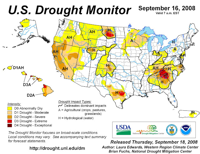
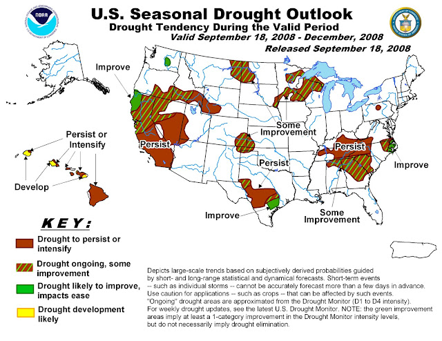
After a dry summer, much of the United States is beginning to see relief as we enter the second half of autumn. According to Douglas Le Comte, drought specialist at NOAA’s Climate Prediction Center, “U.S. drought coverage has decreased from nearly 30 percent between mid-June and early August to about 20 percent now.” Drought severely affected the interior South this summer. Many of this hurricane season’s tropical systems have provided the south with much needed rainfall.
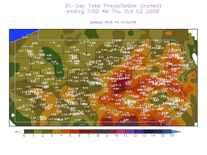
Here in State College, PA, we have seen a substantial change in conditions. During the beginning of the semester, all of the grass was dead and many of the trees were beginning to drop their leaves. Over the last few weeks, the region has seen a substantial change as precipitation has reached Happy Valley. As seen in NOAA’s U.S. Seasonal Drought Outlook, the Centre County area is still listed as having persisting drought conditions.
"NOAA: U.S. Drought Shows Signs of Improvement." National Oceanographic and Atmospheric Administration. 18 September 2008.
Wednesday, October 1, 2008
The Daily Collegian
The CWS Daily Collegian Forecast Discussion for October 1, 2008:
A cold front pushed through the Commonwealth of Pennsylvania in the evening hours yesterday bringing with it a cool start to October. Today, expect dreary and wet conditions as overcast skies and scattered showers persist over the State College area. A west wind blowing moisture from the Great Lakes will allow clouds to dominate the skies over Happy Valley for the remainder of the week. High temperatures will stay below 60 degrees for the remainder of the work week as well. The forecast for Parents’ Weekend calls for a mix of sun and clouds with a return to seasonable temperatures.
A cold front pushed through the Commonwealth of Pennsylvania in the evening hours yesterday bringing with it a cool start to October. Today, expect dreary and wet conditions as overcast skies and scattered showers persist over the State College area. A west wind blowing moisture from the Great Lakes will allow clouds to dominate the skies over Happy Valley for the remainder of the week. High temperatures will stay below 60 degrees for the remainder of the work week as well. The forecast for Parents’ Weekend calls for a mix of sun and clouds with a return to seasonable temperatures.
Subscribe to:
Posts (Atom)


 Posts


