NOTE: This IS NOT Joe Bastardi's winter forecast!
Joe Bastardi came to do our weekly forecast discussion today here at Penn State and he talked about analogs between hurricane seasons and proceeding winters. It was really interesting to hear a forecaster who does it the 'old school' way with analogs vs. some of the new model hugging forecasters. We had a 'bang for the buck' hurricane season and likes the idea of a 'front loaded winter.' I forget the exact analog years he's using. Anyway, he likes to use hurricane seasons as indicators because of the fact that they transport heat away from the equator and toward the poles. Thus, cold air likes to sink and 'fill the gap' left by the warmer air. Therefore, he thinks we will have a lot of cold and possibly snow at the beginning of the winter and wouldn't be surprised to see it break in February with very warm temps and maybe a little more cold in late March/April.
One of the professors that attended the discussion read an e-mail he had just received about major October snow in Pennsylvania and the corresponding winter snowfall. After much research, he concluded that there are 15 analog years where PA has seem accumulating snow fall (I forget how much exactly) and below normal temperatures. This year is one of those years again! In those 15 years, the AVERAGE snowfall in State College, PA was 65" (the average is ~40"). That's 15" above average! He also did some statistics tests to test accuracy of the analogs and they were extremely accurate. I think its a pretty strong correlation.
Come on snow!!
Friday, October 31, 2008
Wednesday, October 15, 2008
Forecast Discussion for Puerto Rico ahead of Hurricane Omar

I wrote this discussion for my Dad who is scheduled to fly into Puerto Rico this week. Its pretty comprehensive so I just figured I'd post it for the heck of it. All data is as of 11PM Tuesday Night (20081015/0300 GMT)
As you wake up this morning, you probably have realized that Hurricane Omar underwent some relatively rapid intensification overnight on Tuesday. Winds increased to 75 mph, and it became a category one hurricane. The National Hurricane Center (NHC) expects the winds to increase to at least 100+ over the next day or two. Personally, I think they might be underestimating the storm, because they have already misjudged Omar's strength. Not to mention its pressure has dropped significantly around the center of circulation (below 980 mb), and the ocean waters ahead of the system remain warm. However, I doubt you will see intensification of the likes of Hurricane Mitch which became a category five storm in an extremely short period of time in the Caribbean almost exactly ten years to date. Nonetheless, it would not surprise me if Omar became a major hurricane as it was passing the island. Fortunately for the island, Omar's hurricane and tropical storm force winds are wrapped tightly around the center of circulation. I do expect the core of winds to expand a little bit over the warm waters; however, the hurricane force winds should spare the central region of Puerto Rico. Regardless, the winds will be the least of your concerns once you are on the ground. Islands around the region are expecting rainfall totals upwards of a foot from the now nearly stationary storm. Puerto Rico will not experience such extreme totals because the storm will begin to increase forward speed as it turns to the ENE away from the island. Currently, Tropical Storm Warnings and Hurricane Watches have been posted for the entire island. The outer rainbands of Omar are just offshore, and will likely interact with the entire island tomorrow. Central Puerto Rico should be spared from the worst of Omar. Barring any rapid intensification, expect periods of heavy rain with localized flooding, coastal flooding associated with storm surge, tropical storm winds (possibly gusting up to hurricane force), and the threat of a tornado. Omar will be just to the SE of the island at 8PM on Wednesday, and will proceed pass to the east of the island. I don't expect widespread devastation from Omar in Puerto Rico, but I know I wouldn't want to fly into this storm.
Sunday, October 12, 2008
Week of 10/12 Forecast Discussion
Hope everyone had a great weekend! The weather was fantastic and very "late summer like" with temps well into the 70s. This was due to a large ridge of high pressure with very high positive anomalies that is still in control over the eastern part of the country. Meanwhile, as Ben mentioned in his Thursday post, places out West are experiencing heavy snowfall for one of the first times this season. This pattern will remain in place for the beginning part of the week but will soon breakdown as we near the weekend.
Look for temps to be well above average tomorrow and Tuesday (some places around the region could see highs into the low 80s as 850mb temps warm to ~15 degrees C. Wednesday will again be a gorgeous day with highs in the 70s. A cold front will "wash out" over the region late Wednesday and Thursday leading to more clouds and cooler temps (back to seasonable levels). We may see a chance of precipitation later in the week if waves of low pressure form along the front. However, at this point showers look "few and far between." Friday and Saturday look nice at this point with normal or below normal temps as a trough digs into the region behind the frontal boundary. Heights lower and 850mb temps cool to 0 degrees C--much more fall like!
Enjoy the nice weather this week...hopefully the rain stays away for the end of the week. Have a good one!
Thursday, October 9, 2008
Rocky Mountain Snowstorm
The NWS has posted Winter Storm Watches for the extreme western Dakotas and large portions of Wyoming and Montana, with the potential for feet of snow to fall from tonight through Sunday night. I’m not going to post a map of my expected snow totals given the very rough topography, but I do believe that the highest amounts will be located around and to the east of Yellowstone National Park.
One thing I would like to get feedback on from readers is how familiar you all are with meteorology, and your willingness to learn more. That way, I can tailor my posts to the appropriate level. I’ll lay out guidelines on how you should rank yourself:
10 = Ph.D. in meteorology.
7 = Junior or senior in undergraduate meteorology
4 = Knows the difference between a weather watch and a weather warning
1 = Eager to learn!
By the way, this is my first blog post, I promise future ones will be better!
Thursday Update
So what has happened since I last wrote? Well, the rain moved in earlier than I anticipated. Rain began to fall around 3:30p yesterday and hung around until just after midnight. I wouldn't even say it was raining, instead, it was misting for most of the time. But now, the "mist" is history and high pressure is back in control. Today and the next few days is looking BEAUTIFUL! Sunny or mostly sunny skies and temps in the low 70s. The forecast is the same as before, but instead of starting Friday, it started today, which is fine with me! Check back for more updates! Peace. -Adam.
Wednesday, October 8, 2008
In conjunction with the Weather Challenge: The Weather Prediction Markets
For all of you involved with the Weather Challenge, and even those who aren't, I encourage you to sign up for the Penn State Weather Prediction Markets. These markets are part of a scientific experiment being run jointly by the Penn State Meteorology Department, the Smeal College of Business and is sponsored by the National Science Foundation. Not only is it a terrific learning opportunity for those interested in weather risk management but a chance to make REAL money with no risk!
It's pretty simple. Basically you will trade contracts known as derivatives that obtain their value based on the high temperature on a given day in a given city.
EXAMPLE: A contract may specify that it will be worth $1 if the temperature in Jacksonville, FL is 82 or 83 on October 7th. If the high temperature on that day is in fact 82 or 83, the contract is worth $1. If however, the high is not within the bounds specified by that contract, in this case <82>83, then the contract is worth nothing.
In terms of the actual trading of these contracts, you can either write (sell) these contracts or you can (buy) them. The market prices that you as a trader sets for these transactions should in theory reflect the degree of confidence in a particular forecast.
EXAMPLE: If the above mentioned contract (KJAX - 10/7/08 - 82/83) is trading around 50 cents, it is reasonable to assume that the market has pegged a 50% chance of the high being 82-83. This is because the contract will be worth 1$ if it hits, or $0 if it doesn't, thus the market price is essentially the expected value of that contract verifying.
Upon signing up and at the start of each new city, you will be given free money and some initial contracts to start off with. Just like in a real market, those with a forecast that veers from the market's expectations stand to either take a big gain or a big loss. The market participants are both meteorology students and business students, so this gives the meteo's a chance to use their forecasting skill to their advantage. Unlike in equities trading, there are very few restrictions on "insider information" when it comes to commodities trading. The cities used for these markets correspond to the WxChallenge making things even more convenient. So don't just forecast for the sake of forecasting, put your forecasts to work and make some money in the meantime.
Feel free to ask me any questions. You can sign up and obtain more information on the following web page:
lema.smeal.psu.edu/prediction (no "www")
Tuesday, October 7, 2008
Tropical Update
Since my last post on Hurricane Ike, three other named tropical storms have formed across the Atlantic. Unfortunately, exams and Penn State Football has dominated my life over the past two weeks, so this is this the first chance I have had to write about them. Anyway...
Hurricane Kyle formed in the Caribbean from a strong tropical low pressure system. Kyle proceeded to strengthen over the Gulf Stream reaching its maximum intensity on September 28th with winds of 80 mph and an estimated minimum pressure of 984mb. Kyle proceeded make landfall in Nova Scotia before becoming extratropical over the cold waters of the North Atlantic. Interestingly enough, the hurricane warnings issued by the Canadian Hurricane Centre. Hurricane advisories were not issued in Canada prior to 2004, but that policy was changed after Hurricane Juan devastated Halifax in 2003.
Tropical Storm Laura formed shortly after Kyle from a strong subtropical wave over the Central Atlantic. Laura never interacted with land, and only held tropical characteristics for a few hours before becoming an extratropical cyclone.
Most recently, Tropical Storm Marco formed just yesterday from a low pressure system in the Bay of Campeche. Marco is an unusually small system, and had tropical storm winds that only extended 15 miles out from the center at landfall. It is without a doubt the smallest named storm in the Atlantic Basin that I have ever seen in my 12 years of being obsessed with tropical meteorology. Marco made landfall this morning in Mexico with winds of 65 mph. Marco will continue to move inland over Mexico, and will likely lose its tropical characteristics later tonight.
Low Pressure for Thursday, High Quickly Follows
See, I told you it would get cold this morning! We got down to 32 degrees here in State College! That was the first time dipping to or below freezing since April 16. Bradford you dropped to 25 and 28 was your low in Clearfield. We rebounded rather nicely though. We are at 59 as of 4:00p with clear skies. Tonight, it will get chilly once again, but I don't think we will get as low as we did last night. I will shoot for mid 30s. Wednesday, we will see those clouds on the increase (but sill mostly to partly sunny) as a low pressure system that brought some severe storms to the southern plains will be approaching. Fortunately, we will not need to worry about severe weather here. The worst of our worries here will just be some scattered light to moderate showers. Rain should hold off until after sundown Wednesday. I'm going to say around 9 or 10p at the earliest. As hinted at before, Thursday doesn't look like it will be that much of a wash out. Although grabbing that umbrella with you as you leave for work or school on Thursday morning isn't a bad idea. Why won't this low be as strong for us as it was the Midwest? Well, the high pressure that is overhead now isn't all about leaving easily. It wants to hang around a little bit longer (which is alright with me!), but the low will have its way in the end. Once the low gets closer, the dry air above us now will help absorb the moisture (whether it be rain precipitating or just clouds) meaning less precipitation that reaches the ground. But enough about my educational rant. After Thursday, it looks like it will dry up as another area of high pressure arrives in time for the weekend. We will see partly to mostly sunny skies in State College with temperatures near 70! But that is another 3 days away. Check back later in the week for another update!
Monday, October 6, 2008
Chilly Mornings, Afternoon Warm-ups Into Tuesday

Photo taken by Adam Del Rosso on 10/6/08.
When you stepped outside this morning, I bet you noticed it was rather chilly. Here in State College, it dropped down to 45. Ok, so 45 isn't that bad, but I thought it was a little nippy. Tomorrow morning, on the other hand, you might want to bundle up a bit more than usual. Temps tomorrow morning are expected to dip down to a down right cold 35 degrees! Clear skies and light winds will allow for exceptional cooling conditions. Frost advisories have been issued for most of the state with freeze warnings farther north where temps could fall below freezing. Both advisories and warnings won't go into effect until overnight. Although, these aren't record low temperatures, they are noticeably below average. Once that sun rises and warms up the ground, things will start to change. It will progressively feel warmer as the day goes on with those clear skies dominating the area. Highs will reach the low to mid 60s which is right where they should be. A light jacket (don't forget those sun glasses too!) is all you should need for the rest of the day. Overall, a typical, beautiful autumn day! Almost a carbon copy of today. Looking beyond Tuesday, the forecast is looking a bit wet. Details tomorrow. Check back!
Thursday, October 2, 2008
Improving Drought Conditions in US
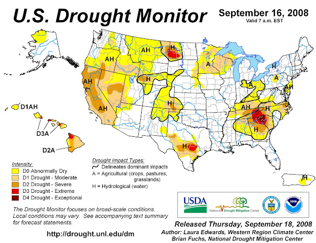
After a dry summer, much of the United States is beginning to see relief as we enter the second half of autumn. According to Douglas Le Comte, drought specialist at NOAA’s Climate Prediction Center, “U.S. drought coverage has decreased from nearly 30 percent between mid-June and early August to about 20 percent now.” Drought severely affected the interior South this summer. Many of this hurricane season’s tropical systems have provided the south with much needed rainfall.
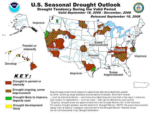
Here in State College, PA, we have seen a substantial change in conditions. During the beginning of the semester, all of the grass was dead and many of the trees were beginning to drop their leaves. Over the last few weeks, the region has seen a substantial change as precipitation has reached Happy Valley. As seen in NOAA’s U.S. Seasonal Drought Outlook, the Centre County area is still listed as having persisting drought conditions.
"NOAA: U.S. Drought Shows Signs of Improvement." National Oceanographic and Atmospheric Administration. 18 September 2008.
Wednesday, October 1, 2008
The Daily Collegian
The CWS Daily Collegian Forecast Discussion for October 1, 2008:
A cold front pushed through the Commonwealth of Pennsylvania in the evening hours yesterday bringing with it a cool start to October. Today, expect dreary and wet conditions as overcast skies and scattered showers persist over the State College area. A west wind blowing moisture from the Great Lakes will allow clouds to dominate the skies over Happy Valley for the remainder of the week. High temperatures will stay below 60 degrees for the remainder of the work week as well. The forecast for Parents’ Weekend calls for a mix of sun and clouds with a return to seasonable temperatures.
A cold front pushed through the Commonwealth of Pennsylvania in the evening hours yesterday bringing with it a cool start to October. Today, expect dreary and wet conditions as overcast skies and scattered showers persist over the State College area. A west wind blowing moisture from the Great Lakes will allow clouds to dominate the skies over Happy Valley for the remainder of the week. High temperatures will stay below 60 degrees for the remainder of the work week as well. The forecast for Parents’ Weekend calls for a mix of sun and clouds with a return to seasonable temperatures.
Subscribe to:
Comments (Atom)


