Finally, now that classes have ended, assignments are no longer due, and the Christmas rush has come and gone, ... It seems like it is time for me to begin my Atlantic Hurricane Season 2008 summary. Much like the National Hurricane Center's summary, my summary will contain information about each and every single storm of the season. However, I plan on interjecting my own opinions, comparisons to previous seasons, and other interesting facts throughout these posts. This summary will be divided up into several different "chapters" that I will post one at a time as I finish them. Some of the sources that I plan on utilizing are NOAA, wikipedia, and possibly some news outlets. I greatly encourage all of our readers to make their own comments on my summary because as much as I'd like to be, I am still not an expert in tropical meteorology. For now I will leave you with a tentative "table of contents" if you will. All the "parts" of the summary will hopefully be published on this site by the time the spring semester starts on January 12th. Until then, I wish everyone a belated Happy Holidays, and a Happy New Year!
EXPECTED "TABLE OF CONTENTS"
Part 1: Quiet Beginnings
-Look back at 2007, preseason expectations, and finally Arthur
Part 2: The Atlantic Warms
-From Bertha to Fay
Part 3: The Peak Months
-Hanna, and introductions to Gustav and Ike
Part 4: Major Hurricane Gustav
-detailed look at Gustav with a look back to Katrina from 2005
Part 5: Major Hurricane Ike
-detailed look at Ike with comparisons to the 1900 Galveston storm
Part 6: Season Finally Winding Down
-From Kyle to Paloma
Part 7: 2008 in Perspective
-conclusions, records, averages, etc, and a look towards 2009
Friday, December 26, 2008
Monday, December 1, 2008
Hurricane Season 2008 Quck Points

Yesterday marked the end of the 2008 Atlantic Hurricane Season. I will post my full season review in a few weeks during winter break. But for now, here are few quick points that I found on the National Hurricane Center's website, and Wikipedia. (the attached image is a product from the NHC during one of the more active parts of this past hurricane season)
2008 Hurricane Season Storms:
(16 Named Storms, 8 Hurricanes, 5 Major Hurricanes)
Tropical Storm Arthur, Major Hurricane Bertha, Tropical Storm Cristobal, Hurricane Dolly, Tropical Storm Edouard, Tropical Storm Fay, Major Hurricane Gustav, Hurricane Hanna, Major Hurricane Ike, Tropical Storm Josephine, Hurricane Kyle, Tropical Storm Laura, Tropical Storm Marco, Tropical Storm Nana, Major Hurricane Omar, Major Hurricane Paloma
Of the 16 named storms: Ike was the strongest and most destructive storm, and Hanna was the deadliest storm.
Some Records: Ike was the third most destructive storm to strike the US. Paloma was the second strongest November storm on record. Ike was the largest storm on record while Marco is believed to be the smallest storm ever named. Fay became the first storm to make four landfalls in the same state. Arthur set a record for being the second May storm in as many years.
Michael's Winter Forecast
As the calendar changes into December and the North Atlantic cools, I begin to shift gears from focusing on tropical meteorology to the impending winter season. While, in no way am I an expert in winter weather, I do enjoy predicting individual winter storms in the "off-season". However, only once before have I made seasonal forecast, so here goes number two...
So far this "winter" (or should I say autumn) has been surprisingly active. November began much warmer than average, but it has been unseasonably cool lately. To date, State College has had about 4" of snow. The seasonal average is approximately 40". This winter, I believe that we will receive at least that much snowfall thanks to active oceans, and an early start to winter. I do not think that we will be on pace to break any records, but 46" of winter precipitation is certainly feasible this season. On the other hand if the coastal storms do not line up again like as they did last year, we could see more ice and rain and below average snowfall. So for now, we will just have to wait and see. I will try to provide forecasts for individual storms as the season develops (not to mention my 2008 Hurricane Season Summary in a few weeks), but for now, just let it snow, and happy holidays to all!
So far this "winter" (or should I say autumn) has been surprisingly active. November began much warmer than average, but it has been unseasonably cool lately. To date, State College has had about 4" of snow. The seasonal average is approximately 40". This winter, I believe that we will receive at least that much snowfall thanks to active oceans, and an early start to winter. I do not think that we will be on pace to break any records, but 46" of winter precipitation is certainly feasible this season. On the other hand if the coastal storms do not line up again like as they did last year, we could see more ice and rain and below average snowfall. So for now, we will just have to wait and see. I will try to provide forecasts for individual storms as the season develops (not to mention my 2008 Hurricane Season Summary in a few weeks), but for now, just let it snow, and happy holidays to all!
Chris' Winter Outlook
'08-'09 Winter Outlook
You probably have been wondering what the '08-'09 winter season will bring. This is something I have been pondering ever since the leaves began to drift towards the ground. By this point in the season, I am usually trying to figure out when the first snowfall of the year might be, but that date has already come and gone. At the beginning of November, I challenged everyone here at the wx blog to create a winter outlook. Since everyone has been so busy, we all decided to put it off until Thanksgiving break. As I sat at home, I set out to create the first of what I hope will be many winter weather outlooks. Mine will probably differ from many of my fellow bloggers because I decided not to limit myself to the confines of Happy Valley. I will be focusing on the State College area as well as Southeastern Pennsylvania.
Below is a picture from MODIS of the Oct 30th snowstorm.
I feel that one of the best ways to start this winter outlook is to reflect on last season ('07-'08). As I am sure many of you remember, La Nina dominated the Pacific Ocean last year. This led to a mild winter season for much of the Mid Atlantic. Southeastern Pennsylvania received one-third of the region’s average snowfall and half of the season’s total fell during one storm. The State College area winter went a little better receiving just below the average snowfall. Both areas experienced above normal temperature with several warm days.
Many would believe that if '07-'08 was dominated by below normal snowfall and above normal temperatures, the '08-'09 season would follow suit. Before we assume this to be true, let’s look at some of the weather patterns that will contribute to this winter season.
The Hurricane Season:
As I am sure you have figured out from Mike’s numerous postings, the 2008 hurricane season was very active. I am surprised that Mike did not blog about the hurricane season officially ending yesterday, November 30. Anyway, if this pattern of activity in the topics continues into the winter season, the Eastern Seaboard could be seeing a few significant Nor’easters.
October and November:
You do not need a climatologist to tell you that both October and November have been slightly cooler than normal. October was the 26th coldest October on 114 year record for Pennsylvania according to NCDC. We saw flurries from lake effect snow entering State College in Mid October and already had a nice snowstorm in most of Southeastern Pennsylvania in November. We have seen an increase in the Northeast snow cover over last year. I expect this pattern of cold weather to continue into the early part of this winter season.

 So far, I seem to be painting a drastically different picture from last season, but we still have a few things to consider.
 El Nino Southern Oscillation (ENSO):
If you like snow, I have good news. It appears that we will not feel the effect of El Nino or La Nina. This is good news because every season with a neutral ENSO has had snowier winters!
Madden-Jullian Oscillation (MJO) and Arctic Oscillation (AO):
It looks like the MJO will be sending moist air from the Pacific to the United States and the AO will send cold air our way. Obviously both are good for a snowy winter.
North Atlantic Oscillation (NAO):
Without ENSO playing a major role in controlling our winter weather, the North Atlantic Oscillation will affect most of our storms. The problem with the NAO is that it cannot be predicted reliably more than one week in advance. For the beginning of December, we can expect the NAO to be negative which means more storms. The NAO is currently negative. If the NAO remains negative for the majority of the season, this winter could be one for the record books.
Okay, now it is time for the hard part. Let me remind you this is the first of what I hope are many winter outlooks.
Southeastern Pennsylvania:

State College:

So why did I differ so greatly on the snowfall. I think that Southeastern Pennsylvania will get most of its snow from Nor’easters and I will not be surprised if the snowfall greatly exceeds my prediction. State College seems to gets most of its snow from Alberta Clippers and lake effect snow. These two factors will probably stay close to normal. Unless a Nor’easter tracks inland, I do not think the Happy Valley will see much snow from this type of system. As far as January and February go, I expect that there will be a warm up in amongst the cold spells. I think that this will happen in beginning of February, but I could be wrong.
I think most snow lovers will be happy with this winter season. I also feel that there is good chance of a White Christmas.
No matter what happens this season, remember to stay safe in adverse conditions. Also, return to this blog for the latest on winter phenomena.
All pictures were taken from the following United States Government Agencies: NOAA, NWS, NASA, and NCDC.
You probably have been wondering what the '08-'09 winter season will bring. This is something I have been pondering ever since the leaves began to drift towards the ground. By this point in the season, I am usually trying to figure out when the first snowfall of the year might be, but that date has already come and gone. At the beginning of November, I challenged everyone here at the wx blog to create a winter outlook. Since everyone has been so busy, we all decided to put it off until Thanksgiving break. As I sat at home, I set out to create the first of what I hope will be many winter weather outlooks. Mine will probably differ from many of my fellow bloggers because I decided not to limit myself to the confines of Happy Valley. I will be focusing on the State College area as well as Southeastern Pennsylvania.
Below is a picture from MODIS of the Oct 30th snowstorm.

I feel that one of the best ways to start this winter outlook is to reflect on last season ('07-'08). As I am sure many of you remember, La Nina dominated the Pacific Ocean last year. This led to a mild winter season for much of the Mid Atlantic. Southeastern Pennsylvania received one-third of the region’s average snowfall and half of the season’s total fell during one storm. The State College area winter went a little better receiving just below the average snowfall. Both areas experienced above normal temperature with several warm days.
Many would believe that if '07-'08 was dominated by below normal snowfall and above normal temperatures, the '08-'09 season would follow suit. Before we assume this to be true, let’s look at some of the weather patterns that will contribute to this winter season.
The Hurricane Season:

As I am sure you have figured out from Mike’s numerous postings, the 2008 hurricane season was very active. I am surprised that Mike did not blog about the hurricane season officially ending yesterday, November 30. Anyway, if this pattern of activity in the topics continues into the winter season, the Eastern Seaboard could be seeing a few significant Nor’easters.
October and November:

You do not need a climatologist to tell you that both October and November have been slightly cooler than normal. October was the 26th coldest October on 114 year record for Pennsylvania according to NCDC. We saw flurries from lake effect snow entering State College in Mid October and already had a nice snowstorm in most of Southeastern Pennsylvania in November. We have seen an increase in the Northeast snow cover over last year. I expect this pattern of cold weather to continue into the early part of this winter season.

 So far, I seem to be painting a drastically different picture from last season, but we still have a few things to consider.
 El Nino Southern Oscillation (ENSO):
If you like snow, I have good news. It appears that we will not feel the effect of El Nino or La Nina. This is good news because every season with a neutral ENSO has had snowier winters!
Madden-Jullian Oscillation (MJO) and Arctic Oscillation (AO):
It looks like the MJO will be sending moist air from the Pacific to the United States and the AO will send cold air our way. Obviously both are good for a snowy winter.
North Atlantic Oscillation (NAO):
Without ENSO playing a major role in controlling our winter weather, the North Atlantic Oscillation will affect most of our storms. The problem with the NAO is that it cannot be predicted reliably more than one week in advance. For the beginning of December, we can expect the NAO to be negative which means more storms. The NAO is currently negative. If the NAO remains negative for the majority of the season, this winter could be one for the record books.
Okay, now it is time for the hard part. Let me remind you this is the first of what I hope are many winter outlooks.
Southeastern Pennsylvania:
- December: 1 degree below normal with average precipitation
- January: 2 degrees below normal with above average precipitation
- February: 1 degree above normal with average precipitation
- March: 1 degree below normal with below average precipitation
- Snowfall: 5-10” above normal

State College:
- December: 2 degrees below normal with below average precipitation
- January: 1 degree below normal temperatures with average precipitation
- February: average temperatures with average precipitation
- March: 1 degree below normal with below average precipitation
- Snowfall: 1-5” above normal

So why did I differ so greatly on the snowfall. I think that Southeastern Pennsylvania will get most of its snow from Nor’easters and I will not be surprised if the snowfall greatly exceeds my prediction. State College seems to gets most of its snow from Alberta Clippers and lake effect snow. These two factors will probably stay close to normal. Unless a Nor’easter tracks inland, I do not think the Happy Valley will see much snow from this type of system. As far as January and February go, I expect that there will be a warm up in amongst the cold spells. I think that this will happen in beginning of February, but I could be wrong.
I think most snow lovers will be happy with this winter season. I also feel that there is good chance of a White Christmas.
No matter what happens this season, remember to stay safe in adverse conditions. Also, return to this blog for the latest on winter phenomena.
All pictures were taken from the following United States Government Agencies: NOAA, NWS, NASA, and NCDC.
Friday, October 31, 2008
Interesting Winter Analog & Joe Bastardi
NOTE: This IS NOT Joe Bastardi's winter forecast!
Joe Bastardi came to do our weekly forecast discussion today here at Penn State and he talked about analogs between hurricane seasons and proceeding winters. It was really interesting to hear a forecaster who does it the 'old school' way with analogs vs. some of the new model hugging forecasters. We had a 'bang for the buck' hurricane season and likes the idea of a 'front loaded winter.' I forget the exact analog years he's using. Anyway, he likes to use hurricane seasons as indicators because of the fact that they transport heat away from the equator and toward the poles. Thus, cold air likes to sink and 'fill the gap' left by the warmer air. Therefore, he thinks we will have a lot of cold and possibly snow at the beginning of the winter and wouldn't be surprised to see it break in February with very warm temps and maybe a little more cold in late March/April.
One of the professors that attended the discussion read an e-mail he had just received about major October snow in Pennsylvania and the corresponding winter snowfall. After much research, he concluded that there are 15 analog years where PA has seem accumulating snow fall (I forget how much exactly) and below normal temperatures. This year is one of those years again! In those 15 years, the AVERAGE snowfall in State College, PA was 65" (the average is ~40"). That's 15" above average! He also did some statistics tests to test accuracy of the analogs and they were extremely accurate. I think its a pretty strong correlation.
Come on snow!!
Wednesday, October 15, 2008
Forecast Discussion for Puerto Rico ahead of Hurricane Omar

I wrote this discussion for my Dad who is scheduled to fly into Puerto Rico this week. Its pretty comprehensive so I just figured I'd post it for the heck of it. All data is as of 11PM Tuesday Night (20081015/0300 GMT)
As you wake up this morning, you probably have realized that Hurricane Omar underwent some relatively rapid intensification overnight on Tuesday. Winds increased to 75 mph, and it became a category one hurricane. The National Hurricane Center (NHC) expects the winds to increase to at least 100+ over the next day or two. Personally, I think they might be underestimating the storm, because they have already misjudged Omar's strength. Not to mention its pressure has dropped significantly around the center of circulation (below 980 mb), and the ocean waters ahead of the system remain warm. However, I doubt you will see intensification of the likes of Hurricane Mitch which became a category five storm in an extremely short period of time in the Caribbean almost exactly ten years to date. Nonetheless, it would not surprise me if Omar became a major hurricane as it was passing the island. Fortunately for the island, Omar's hurricane and tropical storm force winds are wrapped tightly around the center of circulation. I do expect the core of winds to expand a little bit over the warm waters; however, the hurricane force winds should spare the central region of Puerto Rico. Regardless, the winds will be the least of your concerns once you are on the ground. Islands around the region are expecting rainfall totals upwards of a foot from the now nearly stationary storm. Puerto Rico will not experience such extreme totals because the storm will begin to increase forward speed as it turns to the ENE away from the island. Currently, Tropical Storm Warnings and Hurricane Watches have been posted for the entire island. The outer rainbands of Omar are just offshore, and will likely interact with the entire island tomorrow. Central Puerto Rico should be spared from the worst of Omar. Barring any rapid intensification, expect periods of heavy rain with localized flooding, coastal flooding associated with storm surge, tropical storm winds (possibly gusting up to hurricane force), and the threat of a tornado. Omar will be just to the SE of the island at 8PM on Wednesday, and will proceed pass to the east of the island. I don't expect widespread devastation from Omar in Puerto Rico, but I know I wouldn't want to fly into this storm.
Sunday, October 12, 2008
Week of 10/12 Forecast Discussion
Hope everyone had a great weekend! The weather was fantastic and very "late summer like" with temps well into the 70s. This was due to a large ridge of high pressure with very high positive anomalies that is still in control over the eastern part of the country. Meanwhile, as Ben mentioned in his Thursday post, places out West are experiencing heavy snowfall for one of the first times this season. This pattern will remain in place for the beginning part of the week but will soon breakdown as we near the weekend.
Look for temps to be well above average tomorrow and Tuesday (some places around the region could see highs into the low 80s as 850mb temps warm to ~15 degrees C. Wednesday will again be a gorgeous day with highs in the 70s. A cold front will "wash out" over the region late Wednesday and Thursday leading to more clouds and cooler temps (back to seasonable levels). We may see a chance of precipitation later in the week if waves of low pressure form along the front. However, at this point showers look "few and far between." Friday and Saturday look nice at this point with normal or below normal temps as a trough digs into the region behind the frontal boundary. Heights lower and 850mb temps cool to 0 degrees C--much more fall like!
Enjoy the nice weather this week...hopefully the rain stays away for the end of the week. Have a good one!
Thursday, October 9, 2008
Rocky Mountain Snowstorm
The NWS has posted Winter Storm Watches for the extreme western Dakotas and large portions of Wyoming and Montana, with the potential for feet of snow to fall from tonight through Sunday night. I’m not going to post a map of my expected snow totals given the very rough topography, but I do believe that the highest amounts will be located around and to the east of Yellowstone National Park.
One thing I would like to get feedback on from readers is how familiar you all are with meteorology, and your willingness to learn more. That way, I can tailor my posts to the appropriate level. I’ll lay out guidelines on how you should rank yourself:
10 = Ph.D. in meteorology.
7 = Junior or senior in undergraduate meteorology
4 = Knows the difference between a weather watch and a weather warning
1 = Eager to learn!
By the way, this is my first blog post, I promise future ones will be better!
Thursday Update
So what has happened since I last wrote? Well, the rain moved in earlier than I anticipated. Rain began to fall around 3:30p yesterday and hung around until just after midnight. I wouldn't even say it was raining, instead, it was misting for most of the time. But now, the "mist" is history and high pressure is back in control. Today and the next few days is looking BEAUTIFUL! Sunny or mostly sunny skies and temps in the low 70s. The forecast is the same as before, but instead of starting Friday, it started today, which is fine with me! Check back for more updates! Peace. -Adam.
Wednesday, October 8, 2008
In conjunction with the Weather Challenge: The Weather Prediction Markets
For all of you involved with the Weather Challenge, and even those who aren't, I encourage you to sign up for the Penn State Weather Prediction Markets. These markets are part of a scientific experiment being run jointly by the Penn State Meteorology Department, the Smeal College of Business and is sponsored by the National Science Foundation. Not only is it a terrific learning opportunity for those interested in weather risk management but a chance to make REAL money with no risk!
It's pretty simple. Basically you will trade contracts known as derivatives that obtain their value based on the high temperature on a given day in a given city.
EXAMPLE: A contract may specify that it will be worth $1 if the temperature in Jacksonville, FL is 82 or 83 on October 7th. If the high temperature on that day is in fact 82 or 83, the contract is worth $1. If however, the high is not within the bounds specified by that contract, in this case <82>83, then the contract is worth nothing.
In terms of the actual trading of these contracts, you can either write (sell) these contracts or you can (buy) them. The market prices that you as a trader sets for these transactions should in theory reflect the degree of confidence in a particular forecast.
EXAMPLE: If the above mentioned contract (KJAX - 10/7/08 - 82/83) is trading around 50 cents, it is reasonable to assume that the market has pegged a 50% chance of the high being 82-83. This is because the contract will be worth 1$ if it hits, or $0 if it doesn't, thus the market price is essentially the expected value of that contract verifying.
Upon signing up and at the start of each new city, you will be given free money and some initial contracts to start off with. Just like in a real market, those with a forecast that veers from the market's expectations stand to either take a big gain or a big loss. The market participants are both meteorology students and business students, so this gives the meteo's a chance to use their forecasting skill to their advantage. Unlike in equities trading, there are very few restrictions on "insider information" when it comes to commodities trading. The cities used for these markets correspond to the WxChallenge making things even more convenient. So don't just forecast for the sake of forecasting, put your forecasts to work and make some money in the meantime.
Feel free to ask me any questions. You can sign up and obtain more information on the following web page:
lema.smeal.psu.edu/prediction (no "www")
Tuesday, October 7, 2008
Tropical Update
Since my last post on Hurricane Ike, three other named tropical storms have formed across the Atlantic. Unfortunately, exams and Penn State Football has dominated my life over the past two weeks, so this is this the first chance I have had to write about them. Anyway...
Hurricane Kyle formed in the Caribbean from a strong tropical low pressure system. Kyle proceeded to strengthen over the Gulf Stream reaching its maximum intensity on September 28th with winds of 80 mph and an estimated minimum pressure of 984mb. Kyle proceeded make landfall in Nova Scotia before becoming extratropical over the cold waters of the North Atlantic. Interestingly enough, the hurricane warnings issued by the Canadian Hurricane Centre. Hurricane advisories were not issued in Canada prior to 2004, but that policy was changed after Hurricane Juan devastated Halifax in 2003.
Tropical Storm Laura formed shortly after Kyle from a strong subtropical wave over the Central Atlantic. Laura never interacted with land, and only held tropical characteristics for a few hours before becoming an extratropical cyclone.
Most recently, Tropical Storm Marco formed just yesterday from a low pressure system in the Bay of Campeche. Marco is an unusually small system, and had tropical storm winds that only extended 15 miles out from the center at landfall. It is without a doubt the smallest named storm in the Atlantic Basin that I have ever seen in my 12 years of being obsessed with tropical meteorology. Marco made landfall this morning in Mexico with winds of 65 mph. Marco will continue to move inland over Mexico, and will likely lose its tropical characteristics later tonight.
Low Pressure for Thursday, High Quickly Follows
See, I told you it would get cold this morning! We got down to 32 degrees here in State College! That was the first time dipping to or below freezing since April 16. Bradford you dropped to 25 and 28 was your low in Clearfield. We rebounded rather nicely though. We are at 59 as of 4:00p with clear skies. Tonight, it will get chilly once again, but I don't think we will get as low as we did last night. I will shoot for mid 30s. Wednesday, we will see those clouds on the increase (but sill mostly to partly sunny) as a low pressure system that brought some severe storms to the southern plains will be approaching. Fortunately, we will not need to worry about severe weather here. The worst of our worries here will just be some scattered light to moderate showers. Rain should hold off until after sundown Wednesday. I'm going to say around 9 or 10p at the earliest. As hinted at before, Thursday doesn't look like it will be that much of a wash out. Although grabbing that umbrella with you as you leave for work or school on Thursday morning isn't a bad idea. Why won't this low be as strong for us as it was the Midwest? Well, the high pressure that is overhead now isn't all about leaving easily. It wants to hang around a little bit longer (which is alright with me!), but the low will have its way in the end. Once the low gets closer, the dry air above us now will help absorb the moisture (whether it be rain precipitating or just clouds) meaning less precipitation that reaches the ground. But enough about my educational rant. After Thursday, it looks like it will dry up as another area of high pressure arrives in time for the weekend. We will see partly to mostly sunny skies in State College with temperatures near 70! But that is another 3 days away. Check back later in the week for another update!
Monday, October 6, 2008
Chilly Mornings, Afternoon Warm-ups Into Tuesday

Photo taken by Adam Del Rosso on 10/6/08.
When you stepped outside this morning, I bet you noticed it was rather chilly. Here in State College, it dropped down to 45. Ok, so 45 isn't that bad, but I thought it was a little nippy. Tomorrow morning, on the other hand, you might want to bundle up a bit more than usual. Temps tomorrow morning are expected to dip down to a down right cold 35 degrees! Clear skies and light winds will allow for exceptional cooling conditions. Frost advisories have been issued for most of the state with freeze warnings farther north where temps could fall below freezing. Both advisories and warnings won't go into effect until overnight. Although, these aren't record low temperatures, they are noticeably below average. Once that sun rises and warms up the ground, things will start to change. It will progressively feel warmer as the day goes on with those clear skies dominating the area. Highs will reach the low to mid 60s which is right where they should be. A light jacket (don't forget those sun glasses too!) is all you should need for the rest of the day. Overall, a typical, beautiful autumn day! Almost a carbon copy of today. Looking beyond Tuesday, the forecast is looking a bit wet. Details tomorrow. Check back!
Thursday, October 2, 2008
Improving Drought Conditions in US
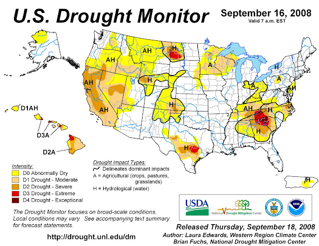
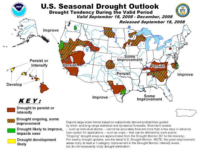
After a dry summer, much of the United States is beginning to see relief as we enter the second half of autumn. According to Douglas Le Comte, drought specialist at NOAA’s Climate Prediction Center, “U.S. drought coverage has decreased from nearly 30 percent between mid-June and early August to about 20 percent now.” Drought severely affected the interior South this summer. Many of this hurricane season’s tropical systems have provided the south with much needed rainfall.
Here in State College, PA, we have seen a substantial change in conditions. During the beginning of the semester, all of the grass was dead and many of the trees were beginning to drop their leaves. Over the last few weeks, the region has seen a substantial change as precipitation has reached Happy Valley. As seen in NOAA’s U.S. Seasonal Drought Outlook, the Centre County area is still listed as having persisting drought conditions.
"NOAA: U.S. Drought Shows Signs of Improvement." National Oceanographic and Atmospheric Administration. 18 September 2008.
Wednesday, October 1, 2008
The Daily Collegian
The CWS Daily Collegian Forecast Discussion for October 1, 2008:
A cold front pushed through the Commonwealth of Pennsylvania in the evening hours yesterday bringing with it a cool start to October. Today, expect dreary and wet conditions as overcast skies and scattered showers persist over the State College area. A west wind blowing moisture from the Great Lakes will allow clouds to dominate the skies over Happy Valley for the remainder of the week. High temperatures will stay below 60 degrees for the remainder of the work week as well. The forecast for Parents’ Weekend calls for a mix of sun and clouds with a return to seasonable temperatures.
A cold front pushed through the Commonwealth of Pennsylvania in the evening hours yesterday bringing with it a cool start to October. Today, expect dreary and wet conditions as overcast skies and scattered showers persist over the State College area. A west wind blowing moisture from the Great Lakes will allow clouds to dominate the skies over Happy Valley for the remainder of the week. High temperatures will stay below 60 degrees for the remainder of the work week as well. The forecast for Parents’ Weekend calls for a mix of sun and clouds with a return to seasonable temperatures.
Friday, September 26, 2008
Tropical Storm Kyle
 I just wanted to get this up on the blog. I will let Mike fill in all the details. This image of the Coastal Watches/Warnings and 5-Day Track Forecast Cone was taken from the NWS National Hurricane Center.
Wednesday, September 24, 2008
Quick Wx Challenge Reminder
Just a quick reminder that the deadline to sign up for the Wx Challenge is this Friday, September 26, 2008.
From September 29, 2008 - October 9, 2008, the WxChallenge will be forecasting for Jacksonville, FL (KJAX). Forecasts are due by 00 UTC.
Here is a link to the US Naval Observatory Master Clock Time.
Many of the bloggers here at The Wx Blog are participating in the Wx Challenge, so expect them to post discussions regarding their forecasts for the current city. No numbers will be posted on this blog until after the submission deadline.
An End to the Nice Weather...
It looks as if the week is going to end on a dreary note after a gorgeous stretch of weather dating back to last week! The high pressure system that has been in control will move off the New England coast tonight and allow a low pressure system to move northward from the waters off the coast of the Carolinas.
This is sort of an odd set up for a weather pattern in this area for this time of year. This pattern reminds me of something we might see in the winter with a Nor'Easter. They can also happen in the fall but late September is usually too soon for Nor'Easters.
The weather should deteriorate quickly in the State College area on Thursday evening with some gusty winds possible in the higher elevations and periods of rain developing overnight. Friday looks to be a dreary day with rain most of the time. The low moves to our North on Friday night and occludes which should lessen the chance for rain on Saturday as the day progresses. In the meantime, a low of tropical origin looks to effect the New England coast this weekend as well...maybe Mike would like to blog on that.
Overall, we've had a great stretch of weather but we are in for some beneficial rain to end the week. On a side note, the game against Illinois looks cool with scattered showers. GO STATE! BEAT ILLINI!
This low will bring high clouds in tonight and tomorrow and eventually rain later tomorrow evening. The clouds are already moving into the SE counties of PA.
The weather should deteriorate quickly in the State College area on Thursday evening with some gusty winds possible in the higher elevations and periods of rain developing overnight. Friday looks to be a dreary day with rain most of the time. The low moves to our North on Friday night and occludes which should lessen the chance for rain on Saturday as the day progresses. In the meantime, a low of tropical origin looks to effect the New England coast this weekend as well...maybe Mike would like to blog on that.
Overall, we've had a great stretch of weather but we are in for some beneficial rain to end the week. On a side note, the game against Illinois looks cool with scattered showers. GO STATE! BEAT ILLINI!
The Daily Collegian
The CWS Daily Collegian Forecast Discussion for September 24, 2008:
The pleasant conditions that have graced the Keystone state will come to an end as we move through the remainder of the week. Today, clouds will mix with sun, as high pressure finally begins to depart. A low pressure system will develop off the coast of the Carolinas tonight and will bring damp conditions to Pennsylvania by the evening hours Thursday. Showers will continue throughout the day Friday and linger into Saturday as fans prepare for the showdown against Illinois. Temperatures will continue to stay near average as highs will remain near 70 for the forecast period.
It looks like the Daily Collegian finally got it right!
Saturday, September 20, 2008
Hurricane Ike In Rare Company
Hurricane Ike's damage estimates are finally coming in from the Gulf Coast. Estimated damage to property is nearly $31 billion (in 2008 US Dollars). $27 billion of the total came from the Gulf Coast of the US, with the other $4 billion coming in from Cuba where Ike made landfall as a category 4 hurricane. If the estimates are correct, Ike will become the third costliest hurricane in US history, behind only Hurricane Katrina and Hurricane Andrew.
Hurricane Gustav, which made landfall earlier this season, caused $17.5 billion worth of property damage, making it the 6th costliest hurricane behind Katrina, Andrew, Wilma, Ike, and Ivan. Interestingly enough 5 of those 6 storms have come since 2004.
Note: I'll write an updated statistical article after the end of the season that will document all of the records that fell during the 2008 Atlantic Hurricane Season.
A Fantastic End to Summer

Tranquil. If I were to describe the weather over the past 6 days plus the next 6, that would be the word. We have seen partly to mostly sunny skies here in State College with temperatures right around where they should be. We have to look back to September 13th to find our last day with precipitation. This past Sunday night/early Monday morning, we did see some higher winds associated with the remnants of Hurricane Ike, but we were sparred from the heavy rains unlike Texas. I clocked a gust up to 41 mph on campus. There were few power outages reported, but nothing compared to western PA and eastern OH. Other than that, it has been beautiful here. People are out and about playing sports, reading or just relaxing. Unfortunately, we are running out of time to do these activities as the days are getting shorter. The sun set today at 7:11p. The picture above is a picture I took on August 30, 2008 of the sun setting from Irvin Hall at PSU. The sun setting early is a sign that the autumnal equinox is quickly approaching. To be exact, it occurs on Monday at 11:44am EDT. I can't believe that summer has already come to an end! So, get outside and enjoy the beautiful weather with rest of daylight that we have!
Friday, September 19, 2008
Regional Roundup & H. Ike Aftermath
 For tomorrow's Penn State vs. Temple game, we will continue to see seasonable weather as a ridge of high pressure dominates the Commonwealth of Pennsylvania. In several areas to our north, a Frost Advisory will remain in effect for the next several days. During the day on Sunday, a weak cold front will push across the State.
Down in Galveston, Texas, efforts are under way to aid the victims of Hurricane Ike. This image, taken from the National Oceanic and Atmospheric Administration's National Geodetic Survey's Hurricane Ike Base Map Image Index Page of the coast along the Blue Water Highway north of Surfside Beach, illustrates the devastation left behind for residents to pickup the pieces.
Wednesday, September 17, 2008
The Daily Collegian
The CWS Daily Collegian Forecast Discussion for September 17, 2008:
The Commonwealth will return to seasonable conditions this week as a high pressure system resides over Happy Valley until the weekend. Today, clouds will dominate the morning skies with some clearing by the afternoon. During the day, temperatures will be normal and cool off to the low 50’s tonight. A mix of clouds and sun will help us get through the week on Thursday and Friday. High temperatures for these days will approach 70 and the low’s for these days will be in the mid to upper 40’s. Nittany Lion fans will look to enjoy promising weather for the big game on Saturday as the high will be in the mid 70’s with mostly sunny skies.
Update (9/17/08 8:30am): The Daily Collegian acreditied the wrong shift again, but everything else was printed correctly.
Saturday, September 13, 2008
Hurricane Ike Rips Through Galveston

Ike previously devastated Cuba as a compact but intense hurricane with winds upwards of 125mph. After crossing the entire island, Ike pushed into the Gulf of Mexico where it began to intensify. Most storms use the warm gulf waters to fuel a small area around the center of circulation, and as a result maximum wind speeds increase dramatically. Ike, on the other hand, spread the energy provided from the gulf over a wide range. Despite a dramatic pressure drop, Ike's maximum wind speeds never eclipsed 110 mph in the Gulf. However, Ike's overall size dramatically increased and hurricane force winds could now be felt over a region spanning 120 miles across.
As Ike moves inland today, the thousands of people (over 40% of Galveston's population) that decided to ignore evacuations will wake up to a different landscape. Storm surge ahead of Ike pulled sea water all across the island. The heavy rain bands around Ike's eye dumped over 2" of rain per hour adding to the flooding. Hurricane force winds battered the island for hours and ripped apart weaker structures. It is going to take a major effort to rebuild this region, as Ike likely did over $1 billion in damage.
Luckily for the Galveston, the hurricane did not pass to the south or east. Therefore, the south winds that develop as a hurricane passes in its lower right quadrant missed the city, and allowed the sea water to drain back into the bay. Nonetheless, Ike was a devastating storm for Galveston, and it's name will likely be retired with Gustav at season's end but, thankfully, the Great 1900 Hurricane still stands alone.
Note: I'll post more on Ike and the rest of the season over the next few days. In particularly, I'll write an article about the devastation in LA from Ike and Gustav, and I'll write an opinion article about the people who didn't heed evacuation orders. Right now, I'm just going to take some time to let the details to come back out of the region.
Wednesday, September 10, 2008
Some Weather Humor
So I thought that I would add a little weather humor to the blog for your viewing pleasure. While all severe weather events should be taken seriously because lives are at danger, it is always good to laugh.
The Daily Collegian
The CWS Daily Collegian Forecast Discussion for September 10, 2008:
The unseasonably warm temperatures and mostly clear skies that we enjoyed after Hanna's departure came to an abrupt end yesterday during early morning hours as a cold front pushed through the Commonwealth. For today, we will see more autumn like conditions and abundant sunshine as a high pressure system dominates the region. By Wednesday night, clouds will begin to enter the region. Clouds continue to build Thursday into Friday before scattered showers finally arrive by Friday evening, bringing a rainy start to the weekend.
Update: (9/10/08 9:00am): We are currently trying to determine why the forecast in the collegian is incorrect.
Update: (9/10/08 10:30am): The Daily Collegian was at fault for today's errors in the paper and on the web.
Sunday, August 31, 2008
The Weather Challenge
Well the registration for the 2008 - 2009 collegiate weather forecasting competition has begun. Make sure you register before the September 28th deadline. This competition allows students to gain a lot of experience forecasting maximum and minimum temperatures, precipitation, and maximum wind speeds for a variety of United States cities. The WxChallenge offers a great opportunity to develop your forecasting skills and have fun! Sign-up today! For information and this years schedule, visit the WxChallenge website.
Once the competition has begun, most of us here at the Weather Discussion Blog will discuss our forecasts. We will not post our numbers on this blog until after the submission deadline.
Once the competition has begun, most of us here at the Weather Discussion Blog will discuss our forecasts. We will not post our numbers on this blog until after the submission deadline.
Thursday, July 24, 2008
Update from Long Beach Island, NJ
Thanks again for setting this up Chris! It's such a great idea. Anyway, I've been on vacation this week in Long Beach Island, NJ (Beach Haven) and I thought I'd give a little weather update from down here.
It has been a very interesting week in regards to the weather. For those who don't know, Long Beach Island (or LBI as it is called by us New Jerseyans) is about 6 miles out at sea and only a mile or so wide at its widest point.
The biggest surprise this week has been the cold water temperatures. The warmest it's been all week is 60 and most of the time the water has been around 57. Brrr.... Due to the cool temps over the water and the higher dew points, we've seen a lot of ocean fog. The beach has been very foggy but the rest of the island is warm and sunny. It's amazing how much the weather changes in 2 blocks down here!
On Wednesday, I got up around 9:30 and it was foggy over the water and sunny over land. 10 minutes later, the entire island was shrouded in fog (it reminded me of the movie The Myst that came out last November...really creepy!). The micro climates down here are extremely interesting; I'm going to try and do some more research on them and hopefully find some more information.
One last note, the lifeguards say that we need a NE wind to warm up the water. That seems counterintuitive to me (one would think a southerly wind would be best). I hope I can figure out this conundrum as well. It's quite annoying that Cape May is reading 80 degrees and Sandy Hook has been in the 70s yet we remain in the high 50s.
Well, there are no pretty graphics in this post unfortunately, but hopefully I can poke around and find out some more about the crazy and changeable weather we've had down here this week. It's too bad I missed the dime sized hail at my house in Somerset County! Have a good one! I'm sure the weather is better in Hawaii Mike!
Wednesday, July 23, 2008
Dolly Slams Southern Texas
 Hurricane Dolly made landfall near South Padre Island in Texas this morning. Dolly was a category two storm packing winds of 100 mph when she came ashore. She is expected to bring up to a foot and a half of rain and up to eight feet of storm surge across the region. Dolly will continue to weaken as it continues to move NW into central Texas. Hurricane warnings are still in effect from San Fernando, Mexico to Corpus Christi, Texas.
Elsewhere, Tropical Storm Cristobal is becoming extratropical over the open waters of the Atlantic as it rapidly moves northeast away from the United States. A tropical wave has also formed off of the coast of Africa and the National Hurricane Center will be observing the system over the next week as it moves to the west at about 20 mph. Any development of this system will be slow to occur.
(Radar imagery taken from NOAA)
Monday, July 21, 2008
AMS Preaching Doom & Gloom
 As if the current economic outlook was not enough to dampen most people’s dreams, the June 2008 issue of the Bulletin of the American Meteorological Society throws salt on our wounds. John A. Knox, a professor of engineering at the University of Georgia, warns the meteorological community about the "recent & future trends in the US undergraduate meteorology enrollment, degree recipients, and employment opportunities" (Knox 873). While Knox brings up many valid points, I do not believe that the prospects in the field of meteorology are as grim as many believe.
The article begins with a great list of the top 4 influences on today’s students entering meteorology. I believe that each item has played a role in many students decisions. While I feel that my passion for meteorology developed before those influences entered my life, each one has reinforced my passion for the subject.
- The film Twister (1996)
- The World Wide Web
- The Mainstream Media
- Weather & Climate topics [Sadly, Hurricane Andrew did not make the list] (Knox 873)
Enrollment Trends and Degree Recipients:
Where do I begin with this one? For one thing, by Knox’s own admission, the data used is incomplete. While the trend is obvious, both enrollment and degree recipients in undergraduate programs have increased. According to Knox’s data, meteorology has had the greatest increase of any major in the physical sciences. Meteorology degree recipients have increased a whopping 161% from 1968-2004 (Knox 874).
Employment Trends:
"During 1994-2004 the growth in demand for meteorologists was approximately 4 times slower than the growth in the supply of new meteorologists" (Knox 877). This statement applies to B.S. meteorologists and employment announcements that require no more than a B.S.
For 2006, only 167 postings in the private sector were for entry-level positions requiring little to no experience. The National Weather Service has only 53 new positions per year and the military has 65 new positions per year. After some basic math, that equals 285 positions available to graduates with a B.S. (Knox 878).
What this means:
Well, the field has become very competitive, but we can take advantage of the information in this article. I came up with several questions that up and coming meteorologists need to ask themselves.
- Should I go to grad school?
- Do I have a minor in a semi-related field?
- Am I going to or in a reputable program?
- What extracurricular activities am I involved in?
- Am I getting satisfactory grades?
- Am I planning to have more than one internship (aka experience)?
- Do I have good social & interviewing skills?
- Am I trying to enter a growing sector within the field of meteorology?
If you can answer yes to several of these questions, then I feel that you will have nothing to worry about.
Knox, John A. "Recent and Future Trends in U.S. Undergraduate Meteorology Enrollments, Degree Recipients, and Employment Opportunities." Bulletin of the American Meteorological Society June 2008: 873-883.
Sunday, July 20, 2008
Dolly Finally Forms
 Well, it's finally official. The tropical low that the National Hurricane Center had been tracking all week has finally become the season's fourth tropical storm, Dolly. As of 5PM, Dolly was located about 230 miles SE of Cozumel, Mexico. She is packing winds of 45 mph, and will dump several inches of rain all across the Caribbean. Dolly will likely make landfall on the Yucatan on Monday before crossing into the Gulf of Mexico later in the day. Latest models indicate that Dolly will gain hurricane strength in the warm waters of the gulf before making it's second landfall in the middle part of the week.
(Rainbow IR satellite image of Dolly above produced by NOAA)
Elsewhere, Tropical Storm Cristobal is impacting the Carolina coastline. Cristobal is a poorly defined system that currently lacks significant thunderstorm activity. However, Cristobal may bring rain to the East Coast before turning up the Gulf Stream and away from land. If you are heading down the shore be careful of dangerous rip currents associated with the system.
Also, we can finally say goodbye to former Hurricane Bertha. Bertha finally lost its tropical characteristics on Sunday over the cold waters of the extreme north Atlantic. Bertha formed way back on the 3rd of July as a weak tropical depression. Eventually Bertha reached hurricane status and topped out as a powerful category three hurricane on the 8th. Bertha weakened over the open waters as she turned northward and made landfall in Bermuda before finally heading out to sea.
I will continue to blog about the 2008 Atlantic Hurricane Season all the way through November 30th and beyond. For additional hurricane information check out the NHC's newly remodeled site www.nhc.noaa.gov
Regional Roundup - SE PA
Tropical Storm Cristobal is moving toward the northeast at eight miles per hour. Cristobal should not be an issue for our area except near the coast. As with Bertha, Cristobal brings an increased risk of rip currents.
Our area is currently experiencing severe thunderstorms. Many counties in the region are under severe thunderstorm watches and warnings. These storms will continue to linger into the midnight hours.
On Monday, a frontal boundary will approach from the northwest. These storms will remain isolated. Hopefully, the next few systems will bring a return to cooler weather to the region by Tuesday or Wednesday.
Saturday, July 19, 2008
Excessive Heat Warning - SE PA
Well, it looks like the National Weather Service still has the city of Philadelphia and the surrounding suburbs under an Excessive Heat Warning. Luckily, the warning expires at 8pm this evening. The region will remain under an Excessive Heat Watch through Monday as the high pressure remains off the coast. If you plan on being outdoors for the remainder of the weekend, please drink plenty of cool water and stay in the shade. Prolonged exposure to this weather can cause several hazardous heat related illnesses.
Update (7/20/08 5:00pm): NWS has extended the Excessive Heat Warning until 8pm Sunday.
Update (7/20/08 5:00pm): NWS has extended the Excessive Heat Warning until 8pm Sunday.
Friday, July 18, 2008
Welcome
Welcome to my weather blog! I will be discussing some interesting weather events, local weather, and the weather challenge forecast cities. Also, expect several friends to post content here as well.
Subscribe to:
Comments (Atom)


